Strasbourg Airport (SXB)
City Orientation and Maps
(Strasbourg, France)
The city of Strasbourg lies in the province of Alsace, on the north-eastern side of France. Strasbourg is particularly close to Stuttgart, Munich and Frankfurt in Germany, while Luxembourg lies to the north-west.
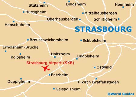
Over the years, the city has gained considerable wealth due to its location, alongside the western bank of the River Rhine, making it well-placed for transportation throughout central Europe. Today, many people choose to fly into the region, at Strasbourg International Airport (SXB). Located on the south-western side of the city, the airport is easy to reach along the D-221 and other nearby main roads.
Strasbourg International Airport (SXB) Maps: Important City Districts
On the western side of Strasbourg you will find the Gare SCNF, which is just a short walk from the cathedral and can be reached along the Rue du Maire-Kuss. A tourism bureau is situated next to the train station, in the new underground shopping centre.
The city's main tourist information centre is located at the Place de la Cathédrale and is open on a daily basis. Worth considering purchasing at the tourism office is the 'Strasbourg Pass', which allows free access to a number of attractions, including the cathedral tower and also a cruise along the Rhine.
Strasbourg's centre is well pedestrianised and contains a number of car parks for those wishing to drive around the city. Modern trams are also a popular way to get around, together with bicycles. In fact, Strasbourg is known for being home to the most extensive network of bicycle lanes in the whole of France.
France Map

Strasbourg Map


